
Multiscale Optical Data
Experiment name:
Exploitation of multiplatform optical data for assessing water quality in Lake Mulargia (Italy) reservoir.
Scientific question:
Which are the more appropriate resolutions of optical remotely sensed data in assessing water quality? How water authorities needs can be fulfilled by multi-scale multi-resolution optical data?
Experiment idea:
The idea is to explore concurrent measurements from in situ, drone, airborne and satellite sensors to analyze the appropriate resolutions depending on user needs.


Background information
In order to improve the monitoring of freshwater reservoirs for water supply, the water authorities might take advantage of using optical remotely sensed imagery. Several satellite sensors have been used since decades for mapping water quality in inland water; in particular in the recent years the improved resolutions of Sentinel-2 and Landsat-8 provide relevant data for also monitoring smaller basins. Meanwhile a fast growing technology has been used to explore advanced sensors (e.g. hyperspectral) and platforms (e.g. drones). By having a such increased observation capability, this experiment aims to evaluate which data might be used for monitoring water quality depending on user needs. The experiment is performed in Lake Mulargia (located in the center of Sardinia, one of the two largest islands of Italy), where the local water manifested different needs depending on multiple factors such as the progression of the season, the alarm due to unexpected cyanobacteria blooms and thermal surface patterns conditioned by riverine inputs.
Leader
ENAS
Short Description
Description of the study area and compilation of the main requirements for assessing water quality
Outcome
The Mulargia is a dammed reservoir build on Flumendosa river located in south Sardinia, the second-largest Italian island. With a surface area of 12 km2 and a capacity of 347 hm3. Mulargia serves as a drinking water source for 700,000 people, as well as for other water uses including agricultural and industrial.
Mulargia serves as a drinking water source for the town of Cagliari with hinterland and for about 20 villages around in the greater area, summing up to a population of 700.000 inhabitants. The total annual abstraction for drinking water purposes is estimated to be 100 hm3. Lake Mulragia also represent a resource for tourism and recreational activities, among which fishery is one of the most relevant so that some specific portion of the lake’s area has been designed for such activity. Then, in amazing and wild setting of central-southern Sardinia Lake Mulargia is visited by an incensing number of people who might appreciate the rugged coastlines, cool, sparkling waters from which little islands emerge.
Ente Acque della Sardegna (ENAS), the local multisector water network manager, constantly transfers water from Flumendosa through a gravity gallery with a capacity of 10 hm3/d, in order to balance levels and meet regional freshwater needs. Beyond assuring local supply, water blending is also used to meet qualitative targets. When algae blooms or turbidity related incidents appear in Mulargia, bringing fresh water from Flumendosa is a way to improve water quality or prevent its deterioration.
The Mulargia waters are in meso-eutrophic state as a consequence of loads of phosphorus mostly due to agriculture and zootechnic, with low transparency and high conductivity representing the most important issues. Chlorophyll-a have minimum concentration in winter seasons and maxima normally occurring in autumn. In autumn a cyanobacteria bloom occurring over the lake surface in the northern regions, where Flumendosa river transports nutrient-rich waters into the reservoir. In this region, besides the river water inflow, low bathymetry facilitates resuspension of nutrients that are present in the sediments. Lowest Chl-a values can be observed in the southern areas, close to the Mulargia dam, where a water caption point is located. Planktothrix rubescens is one of the most genus of cyanobacteria presents in the Mulargia, the depth at which Planktothrix stratifies is therefore explained by buoyancy regulation in relation to the irradiance.
Respect to the turbidity, spring and autumn seasons are generally characterized by greater turbidity as a consequence of meteorological extreme rainfall events.
In order to manage a complex system like Mulargia which is threatened by a variety of challenges like droughts, floods, diffuse pollution and deforestation, ENAS needs advanced and accurate tools to support him in decision making.
In particular from Remote Sensing data the list of need includes:
– Maps of phytoplankton pigments (Chl-a; Pycocyanin, Phycoerythrin)
– Maps of Total Suspended Matter/ Turbidity
– Maps of aquatic vegetation
– Maps of Surface Water Temperature
– Maps of Colored Dissolved Organic Matter
Leader
CNR
Short Description:
Review of scientific literature to show the current state of the art of remote sensing in inland waters from in situ, airborne/UAV and satellite observations with a section focusing on user needs
Outcome
Regular observations of physical and biogeochemical components in inland waters by means of remote sensing imagery provide essential information in the form of maps of tracers concentrations, water quality, bottom properties and bathymetry as needed for science and resource management (e.g., Dekker et al., 2011; Odermatt et al., 2012; Hestir et al., 2015; Kutser et al., 2020). Depending on the scale of observations, the developments in water quality and biophysical parameter retrieval algorithms are driven by airborne and spaceborne hyperspectral sensors (e.g., AVIRIS, APEX, MIVIS, Hyperion, HICO), ocean colour (OC) radiometry (e.g., MODIS, MERIS, Sentinel-3) and multispectral sensors (e.g., Landsat, Sentinel-2).
In the last decades, significant progress has been made in studying coastal and inland waters using global OC sensors such as MODIS and MERIS (e.g., Giardino et al., 2010; Bresciani et al., 2011; Odermatt et al., 2012; Lenstra et al., 2014; Blondeau-Patissier et al., 2014; Bresciani et al., 2014; Giardino et al., 2014a). More recently, the Copernicus Sentinel-3/OLCI instrument offers an improved mapping potential for its specific capacities to resolve turbid, productive waters and for having daily revisit with a 300-m pixel (e.g., Cazzaniga et al., 2019; Bresciani et al., 2020), whereas the Copernicus Sentinel-2/MSI can provide data at a higher spatial resolution every 5 days. Multispectral sensors on-board Landsat-8 and Sentinel-2 satellites are not specifically designed for observing aquatic ecosystems but they are suitable for detailed water quality analysis: successful examples of the use of these new sensors are provided by Hedley et al., (2018) for mapping bathymetry in shallow water environment, Giardino et al., (2014b) for subalpine lakes, Villa et al., (2015) for mapping macrophytes, Giardino et al., (2017) for rivers and Brando et al., (2015) and Braga et al., (2017) for river plumes. However, progress from the measurements of basic parameters to quantitative understanding of various biophysical and biogeochemical processes in these waters has been hindered by the limited capabilities of these sensors. In coastal and inland waters optically active constituents (OACs) often vary independently requiring improved spectral and radiometric resolutions, while physical drivers such as tides and geographic boundaries set up different spatial and temporal scales compared to the open ocean, requiring improved resolution than what is currently provided by existing space-based assets (Brando et al., 2015; Hestir et al., 2015; Giardino et al., 2019).
Airborne Imaging Spectrometry High-resolution airborne hyperspectral sensors (e.g., AVIRIS, AISA, HyMAP, PRISM, APEX) represent enhanced mapping tools, but are limited in spatial coverage and revisit times. These airborne systems provide optimal resolutions for developing inland and water quality applications at fine scale (e.g. Dekker et al., 2001). In particular, airborne imaging spectrometry has been used to make medium-scale inventories of macrophytes, seagrasses and corals (Alberotanza et al., 1999; Dekker et al., 2007; Giardino et al., 2007a; Bresciani et al., 2012; Villa et al., 2017, Kutser et al., 2020). The airborne technology has the merit of providing preliminary tests to design satellite-based systems. For example, Kallio et al., (2001) and Giardino et al., (2005) used airborne AISA and MIVIS images, respectively, for simulating MERIS data on lakes. More recently APEX data have been used to define and validate algorithms for mapping primary producers in eutrophic lake waters (e.g. Bolpagni et al., 2014; Hestir et al., 2015). Satellites Imaging Spectrometry Modern spaceborne hyperspectral sensors (e.g., HYPERION, CHRIS-PROBA and HICO from the ISS) show increasing capabilities in inland and coastal water applications (Brando and Dekker 2003; Giardino et al., 2007b; Santini et al., 2010; Braga et al., 2013), although their SNR might be limited in making accurate measurements of moderate changes in water quality parameters (e.g., CDOM with Hyperion in clear lakes (Giardino et al., 2007b)).
In this context, the current and future hyperspectral satellite missions are progressing showing similar (30 m spatial resolution of the satellite systems EnMAP and PRISMA, and DESIS and HISUI on-board of ISS). These missions will extend the knowledge that so far has been primarily driven by Hyperion (e.g., Brando and Dekker, 2003; Giardino et al., 2007) and HICO (e.g., Braga et al., 2013; Garcia et al., 2014) with increased spectral and radiometric resolution. They will also allow to make progress in inland and coastal waters applications although, being designed for a variety of applications, might still have some limitations in measuring the remote sensing reflectance (e.g., low) over water bodies.
Most of the challenges in inland and coastal water observations are due to their optical complexity (Hestir et al., 2015; Giardino et al., 2019). These aquatic ecosystems can be a mixture of optically shallow and optically deep waters, with gradients of clear to turbid and oligotrophic to hypertrophic productive waters and varying bottom visibility with and without macrophytes (Odermatt et al., 2012; Giardino et al., 2015; Giardino et al., 2019; Kutser et al., 2020). For example, a lake receives and recycles organic and inorganic substances from within the lake, from its watershed and beyond (atmospheric deposition). Hence, a large range in optical absorption and backscattering resulting in high optical variability due to the dissolved and suspended organic and inorganic material in the water column and the reflectance of the bottom can be found among and within lakes, estuaries and coastal waters. This poses a challenge for bio-optical algorithms applied to optical remote sensing for water quality monitoring applications. Another challenge is performing atmospheric corrections over such variable aquatic ecosystems as their complexity requires different approaches than those for land and ocean applications. High spectral resolution data provides the spectral bands and information redundancy needed for accurate biogeochemical parameter retrievals (Dekker et al., 2001; Bresciani et al., 2013; Hestir et al., 2015) from water bodies that have complex interacting processes influencing the measured spectra. The visible and near infrared regions (400–800 nm) are the most relevant part of the spectrum for measuring the absorption and scattering properties and the suspended and dissolved materials in the water column. PRISMA imaging spectroscopy in this spectral range should provide both a better estimation accuracy of inland and coastal water variables and new products for multiple inland and coastal water applications.
Developing applications for inland and coastal surface waters, for the water column and for benthos from satellite remote sensing requires high spatial, spectral and temporal resolution and the highest possible radiometric resolution (Dekker et al., 2017; Muller-Karger et al., 2018; Giardino et al., 2019). Imaging spectrometry has clear advantages over multispectral sensors for aquatic ecosystem monitoring. For example: a sensor with multiple contiguous spectral bands from blue to near-infrared wavelengths and for very turbid waters also to the short-wave infrared allows switching between the different wavelengths or wavelength combinations where reflectance features are present; a similar sensor is necessary to discriminate phytoplankton types and to assess the concentration of associated pigments, as suggested by Wolanin et al., (2016). Overall, the availability of a contiguous spectrum makes algorithms more effective in a wide variety of waters with varying water column depths and bottom reflectance and lead to more successful retrieval of a larger number of properties (Brando and Dekker 2003; Giardino et al., 2007b; Brando et al., 2009; Braga el al., 2013; Giardino et al., 2015; Hestir et al., 2015). This combination of factors points to the great utility -effectively a requirement- of hyperspectral data for inland and coastal waters retrievals. This proposal thus includes the development and evaluation of novel PRISMA products that will enable more accurate estimates of optically active water constituents (chlorophyll, suspended matter and coloured dissolved organic matter), more sophisticated products such as particle size distributions or distinguishing sources of suspended and coloured dissolved matter, transparency measures, attenuation coefficient and euphotic depth, the presence of cyanobacteria and harmful algal bloom, estimating water depth and floating matters. Moreover, the algorithms adopted to retrieve these novel PRISMA products will benefit of the increased spectral and radiometric resolution compared to previous spaceborne imaging spectrometers (i.e. Hyperion and HICO).
Apart from spectral resolution, spatial resolution is also a key factor to be considered. Medium to high spatial resolution is required for smaller to larger areas (rivers, lakes, lagoons, estuaries, bays) which generally show patchy and inhomogeneous features (Ozesmi and Bauer, 2002). Giardino et al., (2019) suggested that a 8 m pixel was as trade-off in sensor and mission requirements for regional scale mapping of corals, while a 4 m pixel would still be a bottleneck for shallow water mapping in small lakes. For this reason, the proposal will also include a dedicated activity on PRISMA resolution enhancement that will generate a pan-sharpened PRISMA hyperspectral data cubes with a 5 m GSD, and 10 nm spectral resolution.
Water quality is a prerequisite to meet the United Nations Sustainable Development Goals by 2030 (https://www.un.org/sustainabledevelopment/), notably 6 (Clean Water and Sanitation) to “ensure availability and sustainable management of water and sanitation for all” and No. 14 (Life Below Water) to “conserve and sustainably use the oceans, seas and marine resources for sustainable development”. There is an increasing need for regular monitoring of inland and coastal waters to support national and international directives and conventions such as the US Clean Water Act & Safe Drinking Water Act and the Australian Reef Water Quality Protection Plan, requiring biological, hydro-morphological and physic-chemical parameters of water bodies to be monitored on a regular basis. Several European directives aim at sustainable management of inland and coastal waters, retaining or restoring a high ecological status and safeguarding ecosystem services. The Water Framework Directive (WFD, 2000/60/CE) formed since 2000 the legislative framework for the water management undertaken by the EU Member States aimed at a “good surface water status” for all European water bodies by 2015 both with respect to the ecological status (healthy ecosystems) and the chemical status (low pollution). In Italy, the determination of the trophic status of inland, coastal and transitional ecosystems, according to the WFD, is implemented by the Regional Agencies for Environmental Protection (ARPAs) that activated multi-annual monitoring programs. The Marine Strategy Framework Directive (MSFD, 2008/56/CE) and the Maritime Spatial Planning Directive (MSPD, 2014/89/EU), aimed at support the sustainable development of seas and oceans and to develop coordinated, coherent and transparent decision-making in relation to the Union’s sectorial policies affecting the oceans, seas, islands, coastal and outermost regions and maritime sectors. The Integrated Coastal Management (ICM) are put in place to ensure sustainable management of the coastal resources. The EU Habitats Directive, Drinking Water Directive, Bathing Water Directive, Natura 2000 were established to protect specifically unique and valuable habitats, drinking water resources, and ensure healthy bathing water. These directives ensure that the collective pressure of all activities is kept within levels compatible with the achievement of good environmental status and that the capacity of aquatic ecosystems to respond to human-induced changes is not compromised, while enabling the sustainable use of waterbody goods and services by present and future generations. Likewise, environmental regulations for e.g. dredging activities (e.g. fairway maintenance) and aquaculture are becoming very rigorous and ask for a detailed Environmental Impact Assessment (EIA) and water quality monitoring to evaluate changes into the system.
Leader
CNR
Short Description
Description of the experimental campaign in lake Mulargia involving the use of multiplatform optical sensors
Outcome
This section provides a description of the activities of experimental campaign performed in Lake Mulargia in the week of 21-25 September 2021.
Airborne acquisitions: Lake Mulargia and Flumendosa, Sardinia, Italy
The acquisition took place on 24 September 2020 and includes two different areas of interest (Lake Mulargia and Flumendosa) in the morning (11:30-12:32 GMT) and one in the afternoon (17:30-18:16 GMT). The following figure 1 illustrate the spatial position of the individual strips.
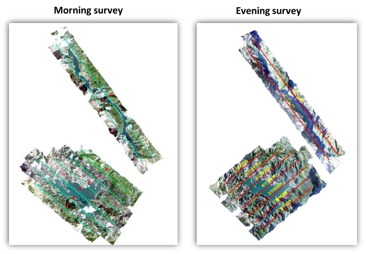
Figure 1: Coverages of the Morning and Evening airborne survey.
The survey was performed using the Hyspex VNIR 1800 (https://www.hyspex.com/hyspex-products/hyspex-classic/hyspex-vnir-1800/). The sensor acquired in a spectral range of 400-1000 nm with a spectral sampling of 3.26 nm for a total of 186 spectral channles (some examples in Figure 2), with a field of view of 16.5 deg.
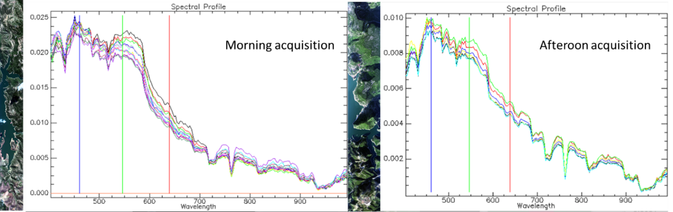
Figure 2: Some spectral profile acquired on the Morning and Evening airborne acquisition.
The survey was carried out an a flight altitude of 3000 m, the ground resolution values obtained were equal to 2 meters and the lateral overlap between the strips was planned at 30%. The high value of lateral coverage has also made it possible to eliminate some cloud formations present in one strip and not in others, allowing for complete coverage of Lake Mulargias. The speed of the aircraft during the survey was about 150 knots. During the survey, GPS receivers were activated on the ground to record GPS signals with characteristics similar to the on-board instrumentation and simultaneously with the execution of the flight, in order to subsequently georeference the acquired images.
UAV acquisitions:
UAV flights have been carried out using a fixed wing drone, the kind of used Drone is known as EBEE X developed by Sensefly, a Parrot group Company with a weight of 1.4 kg with installed two sensors:
- Duet T: Thermal radiometric infrared (FLIR) and RGB (senseFly S.O.D.A.); RGB resolution: 5,472 x 3,648 px (3:2); Thermal resolution: 640 x 512 px.
- MicaSense RedEdge-MX: Five band multispectral sensor:
Blue (475 nm center, 20 nm bandwidth);
Green (560 nm center, 20 nm bandwidth);
Red (668 nm center, 10 nm bandwidth);
Red edge (717 nm center, 10 nm bandwidth);
Near-IR (840 nm center, 40 nm bandwidth).
The acquisition took place on 23 (Mulargia Dam-set) and 24 September (Mulargia West-Set) 2020 as showed in figure 3; the first day the acquisition consist in 2 flights:
- flight 1: has been performed using MicaSense RedEdge-MX as first payload, it is described as follow: Start: 14.04 pm, Duration: 26 min, Altitude: 400 AMSL or 150 meters above water surface, GSD: 10 cm/px.
- flight 2: has been performed using DUET-T as second payload, it is described as follow: Start: 16.03 pm, Duration: 19 min, Altitude: 400 AMSL or 150 meters above water surface, GSD: 19 cm/px.
During day 2 acquisition carried out for points grouped into the Mulargia West-Set:
- flight 1: has been performed using MicaSense RedEdge-MX as first payload, it is described as follow: Start: 10.52 am, Duration: 26 min, Altitude: 380 AMSL or 130 meters above water surface, GSD: 8 cm/px.
- flight 2: has been performed using DUET-T as second payload, it is described as follow: Start: 12.02 pm, Duration: 27 min, Altitude: 380 AMSL or 130 meters above water surface, GSD: 16 cm/px.
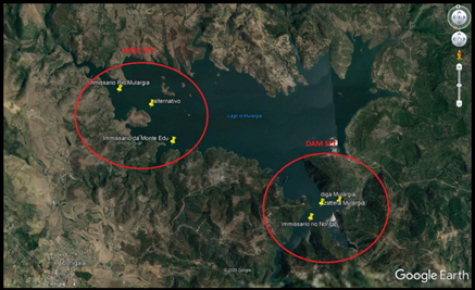
Figure 3: Dam set and West set with points of interest.
Satellite acquisitions:
During the week of field campaign (21-25 September) we have requested the acquisition of hyperspectral images over lake Mulargia and Flumendosa.
PRISMA acquired on 22 September (unfortunately during the acquisition the clouds coverage over the lake was very higher and the signal was much conditionate).
In addition to hyperspectral images for the week of experiment we have the possibilities to use:
LANDSAT-8 (OLI-TIRS) acquired on 23 September.
Sentinel-3 (OLCI) acquired on 24 September.
Sentinel-2 (MSI) acquired on 25 September.
Field data:
The field campaign was performed by CNR-IREA and ENAS during a week of 21-24 September 2021.
The principal activities performed was:
- Installation on a platform of a spectroradiometer (ROX-JB) operating in continuous to measure In-water radiometry measurements;
- Water sampling for lab analysis (Chl-a, CDOM, TSM, Phytoplankton counts and composition, nutrients, chemical analysis);
- In situ water physical parameters measurmants (Tmperature, Transparency, Depth, Wind speed);
- Spectroradiometric (WISP-3; Spectral Evolution SR 3500) measurements for Water surface reflectance;
- Inherent water optical properties measurements: absorption (water sample collection for subsequent filtration with filter path techniques method) and back-scatting (with Hydroscat bb6);
- Spectroradiometric measurements of invariant surfaces;
- Photometric (Microtops) measurements for aerosol and atmospheric humidity quantification.
In total was collected data in 18 different sites for water quality and 20 sites for radiometric measurements (Figure 4).
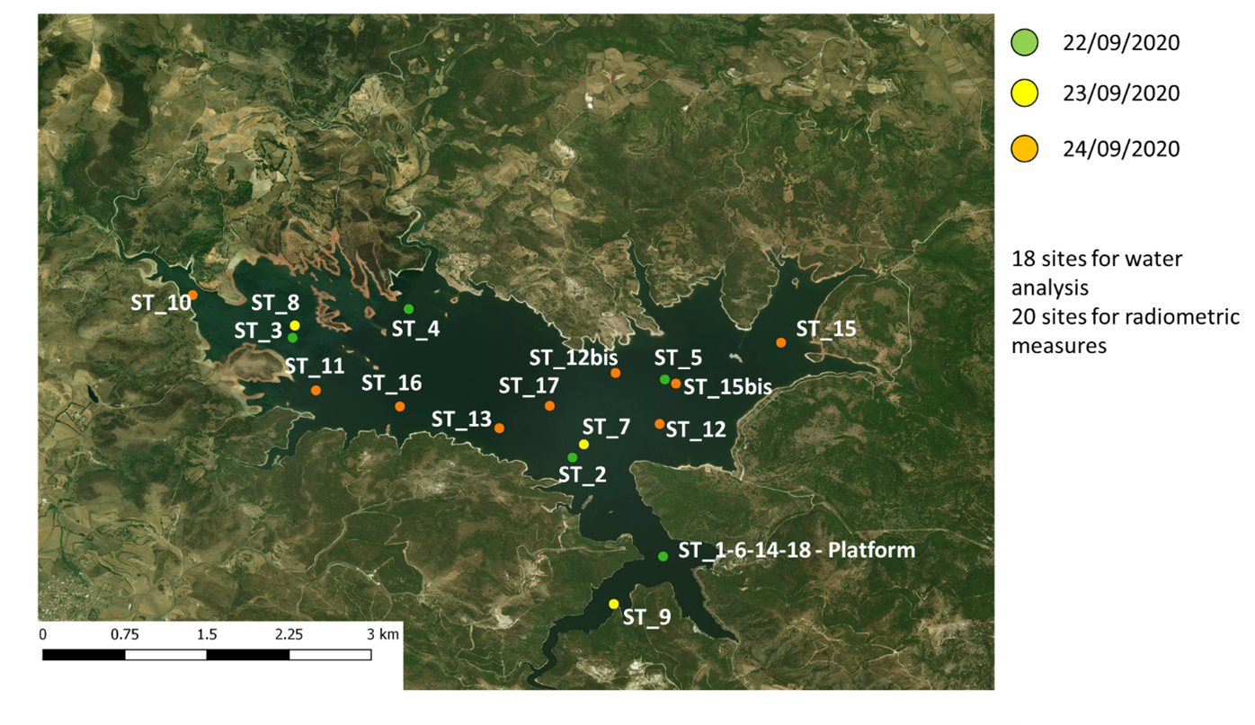
Figure 4: Location of different sampling station in Lake Mulargia.
Leader
CNR
Short Description
Pre-processing of all measures gathered during the experimental campaign to convert raw data into products (e.g., Level 1 and Level 2 satellite products; concentrations of water quality parameters; remote sensing reflectance from field spectrometry)
Completed
Mar. 2021
Outcome
This section provides a description of processing of the data acquired during the experimental campaign performed in Lake Mulargia in the week of 21-25 September 2021.
A number of products have been generated in this task; for each of them short description is provided while Figure 1 show the overall concept used for the processing of remotely sensed hyperspectral imagery data.
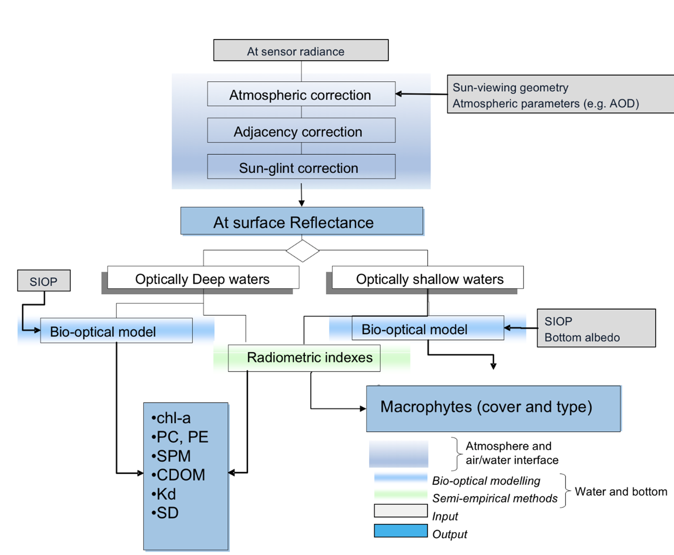
Fig. 1: basic draw of the flowchart used to process remotely sensed data; with chl-a: chlorophyll-a, PC: phycocyanin, PE: phycoerythrin, SPM: suspended particulate matter; CDOM: colured dissolved organic matter; Kd: attenuation coefficient of the downwelling solar irradiance;
The generation of water quality products from optical remotely sensed data basically involves two main processing steps, which are sketched in figure 1. The first step regards the effects that atmospheric path produces on the signal so that there is the need to corrected for the atmospheric effects (as well as the other source of radiometric disturbance). Such procedure aims to estimate the water leaving reflectance. Water leaving reflectance is then the key input for enabling the retrieval of water quality paraments. In particular, the proposed algorithms estimating phytoplankton pigments and macrophytes can be distinguished by two approaches: semi-empirical and bio-optical modelling. the algorithms to estimate water quality are those as described in Experiment 1.
Generally a procedure and to be defined to take into account of absorption and scattering phoneme.
Accurate atmospheric correction is a key step to obtain accurate water reflectance signature, and thus accurate WQPs maps. For inland and coastal waters, in addition, this step is made more challenging by:
- the presence of optically complex waters, which hinder the use of traditional atmospheric correction methods;
- the strong impact over the signal of adjacency effect, due to the small size of the lakes or their narrow shape or the proximity to the coast (brighter than water surfaces);
- the variability of aerosol composition, which strongly affects atmospheric and electromagnetic signal interactions.
Airborne processing
The images (Raw-Data) were acquired by the VNIR sensor with 186 bands and recording 16 bits / pixel / band; The first step in data processing was their radiometric correction. The sensor consists of a CCD made up of single pixels, which have different and nonhomogeneous response characteristics; radiometric calibration was performed on each individual sensor to eliminate this effect and to make the spectral response uniform. To avoid losing any spectral information, the radiometrically corrected data is recorded in 32 bits per channel starting from the original 16 bits. The data was geometric corrected using the PARGE software (https://www.rese-apps.com/software/parge/index.html). the software performed the correction and georeferencing of the data, obtaining the geometrically correct final strip, with the final resolution value set equal to 2 meters and correctly positioned in the chosen reference system. Regarding the image resampling method, the “nearest neighbor” was used to keep the radiometric content unaltered in the transformation.
Respect to the atmospheric correction the airborne data was corrected using ATCOR-4 Radiative Transfer Code Software (http://www.rese.ch/products/atcor/atcor4/) speceifically parametrized for Hyspex imagery.
The atmospheric correction of airborne images are in progress.
UAV processing
The conversion of raw UAV data in reflectances and thermal data are in progress.
Satellite processing
The satellite processing is accomplished as experiment 1 and according to EoMAP procedure.
Field data
In situ data and metadata is available here.
Leader
CNR
Short Description
Computation of accuracy of remotely sensed
Completed
Oct. 2021
Outcome
Computation of accuracies of water quality parameters retrieved from multi-scale, multi-platform optical data
Leader
ENAS
Short Description
The products generated by the experimental campaign are analyzed in terms of pro and cons depending on needs defined by the water authority
Completed
Apr. 2022
Outcome
Generation of a matrix where multi-scale optical data are crossed with user needs
Leave a Reply
You must be logged in to post a comment.