
Measuring Lake Surface Temperature from Space
Water surface temperature is the result of the energy balance at the water surface and heat transport mechanisms within the water body. It is an important water quality parameter related to biodiversity in lakes and knowledge of this parameter is needed to characterize processes at the water surface.
Lake surface temperature reflects meteorological and climatological forcing more than any other physical lake parameter. It is strongly related to the mean temperature of the upper stratum(top layer of water), which plays an important role in lake’s biology depending, among other factors, on the dynamics of phytoplankton. In polymictic lakes, with shallow bottoms and continuous mixing of water layers, surface temperature is similar to water temperatures throughout the water column. In monomictic deep lakes, surface temperatures might be related to the water stratification and the thermocline structure as suggested by Dessì et al. 2011.
Water temperatures are also key climatologic parameters: global climate change and global eutrophication are part of changing environmental factors that strongly influence the status of lake waters. Lakes are very sensitive to climate variations and different studies (e.g. Battarbee et al. 2008) have shown how modification of both air temperature and precipitation regimes determines deterioration of water quality. Water temperature is one of the most important parameters determining ecological conditions in lakes, because it influences water chemistry as well as biological processes of lakes.

According to Pareeth et al. (2017), subalpine Italian lakes are showing a clear response to climate change with an increase of 0.017 °C /year of lake surface temperature, where human activities contribute to produce a large impact (agriculture, recreation, industry, fishing and drinking) on these lakes.
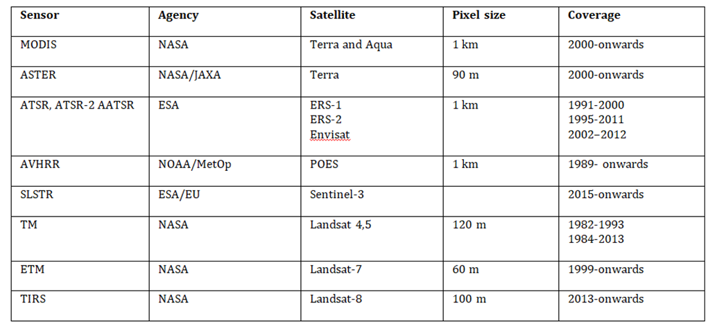
For three decades, remote sensing provides continuous data for observing spatial and temporal variations of lake surface temperatures worldwide (Table 1). Most of the studies have been based on moderate spatial resolution sensors (pixel size of about 1 km), such as MODIS (e.g. Reinart and Reinhold 2008; Bresciani et al. 2011), which provides monitoring on a daily-basis.. Nevertheless, the use of these sensors in smaller lakes is challenging because their spatial resolution is too coarse. In this case, Landsat, a joint NASA/USGS program providing the longest continuous space-based record of Earth’s land in existence, represents the main source of data (pixel size in the order of 100 m) (Wloczyk et al. 2006), yet it has a poorer revisiting time (once every16 days).
Tab. 1 (Not exhaustive, acronyms not specified for sake of brevity) list of optical satellite instruments contributing to the measurement of lake surface temperature.
Exploiting Landsat data for the SPACE-O case studies
The Thermal Infra-Red Sensor (TIRS) on board of the Landsat-8 satellite is providing the principal source of data for measuring lake surface water temperature in the SPACE-O study areas. TIRS data are then used, in combination with spectral information obtained from the optical sensor (namely, OLI) on board the TIRS on Landsat-8, to characterise the heat fluxes and the evaporation rate in the study areas.
First, lake surface temperatures are retrieved from top-of-atmosphere brightness temperature in the TIRS band 10 (10.9 μm). Then, the surface energy budget for the Mulargia and Aposelemis reservoirs is estimated using Landsat-8 derived products (i.e. surface temperature and surface albedo) and other meaurements including, surface air temperature, wind speed, and relative humidity data from the hydro-meteorological surface meteorological stations, (process explained in greater detail inHassan, 2013).
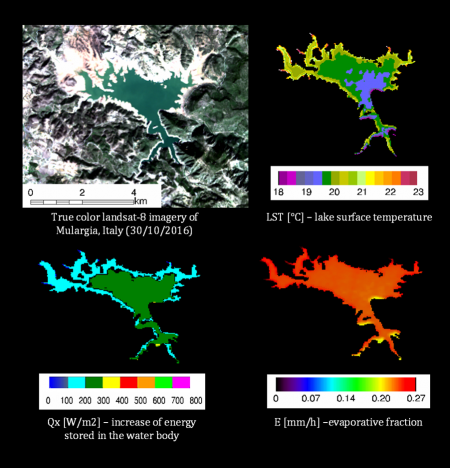
An example of maps describing physical quantities in Mulargia reservoir are shown in Figure 1. It presents the pseudo true colour Landsa-8 image acquired on 30 October 2016, and the three maps describing the lake surface temperature (LST, in °C degree), the increase of energy stored in the water body (Qx, in W/m2) and the evaporation rate from the water body (E, in mm/h).
These data have been generated for both Mulargia and Aposelemis reservoirs, for the time window from 2015 to 2017; a total of 150 images have been processed for each case study.
These data represent an important scientific outcome of SPACE-O. Precise studying of the elements contributing to the water balance of Mulargia and Aposelemis dams is in fact very crucial for better management of these water resources, in particular with regards to managing water quantity. Figure 1 confirms that evaporation is significant at Mulargia and Aposelemis reservoir.In fact, evaporation is considered an important factor in the water balance system that causes a great deal of water loss from these lakes.. Satellite derived imaging of lake surface temperature, lake energy storage and evaporation rate can help support decision-making through the SPACE-O platform and lead to greater water security in the face of climate change and growing demands on limited freshwater resources.
References
Battarbee R.W., Kernan M., Livingstone D.M., Nickus U., Verdonschot P., Hering D., Moss B., Wright R., Evans C., Grimalt J., Johnson R., Maltby E., Linstead C. Skeffington, R. (2008) – Freshwater ecosystem responses to climate change: the Euro-limpacs project. In: Quevauviller, P.; Borchers, U.; Thompson, C. and Simonart, T. (eds.). The Water Framework Directive – Ecological and Chemical Status Monitoring. John Wiley and Sons. pp. 313-354.
Bresciani, M., Giardino, C., & Boschetti, L. (2011). Multi-temporal assessment of bio-physical parameters in lakes Garda and Trasimeno from MODIS and MERIS. Italian Journal of Remote Sensing/Rivista Italiana di Telerilevamento, 43(3).
Dessì, F., Melis, M. T., Murenu, M., Ortu, A., Marini, A., & Cau, A. (2011). Applicazione del prodotto oceanico MODIS per la misura della SST alle acque marine della Sardegna. Rivista Italiana di Telerilevamento/Italian Journal of Remote Sensing, 43(1), 33-44.
Hassan, M. (2013). Evaporation estimation for Lake Nasser based on remote sensing technology. Ain Shams Engineering Journal, 4(4), 593-604.
Pareeth, S., Bresciani, M., Buzzi, F., Leoni, B., Lepori, F., Ludovisi, A., Morabito, G., Adrian, R., Neteler, M. and Salmaso, N., 2017. Warming trends of perialpine lakes from homogenised time series of historical satellite and in-situ data. Science of The Total Environment, 578, 417-426.
Reinart, A., & Reinhold, M. (2008). Mapping surface temperature in large lakes with MODIS data. Remote Sensing of Environment, 112(2), 603-611.
Wloczyk, C., Richter, R., Borg, E., & Neubert, W. (2006). Sea and lake surface temperature retrieval from Landsat thermal data in Northern Germany.International Journal of Remote Sensing, 27(12), 2489-2502.
This blog was written by National Research Council of Italy – Institute for the Electromagnetic Sensing of the Environment (CNR-IREA) & EOMAP GmbH & Co.KG.
If you are interested in joining the discussion on the use of Earth Observation for Improved Water Management, visit our discussion group dedicated to the topic at the International Water Association’s IWA Connect. If you are not yet a member of IWA Connect, you can easily join as a network member for free here. Once you are logged-in, you can access the discussion group here.
Store News
