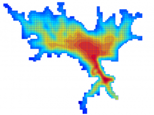
Mulargia bathymetric data
0
Description
This dataset includes bathymetric data for Mulargia reservoir (Sardinia), which were extracted from a raster dataset of 30 m x 30 m resolution that contained three fields: latitude (UTM 32N), longitude (UTM 32N) and elevation (meters). Three different database sources were combined and interpolated for the production of the bathymetric raster: the Shuttle Radar Topography Mission (SRTM) digital elevation model, a military map (19/9/1882, No.1012), and data on water level variations from 1985 to 2016.

Links
Area of interest
Leave a Reply Cancel reply
You must be logged in to post a comment.
Contact info
Related Datasets
- EO-derived Secchi disk depth for Mulargia and Flumendosa reservoirs using Sentinel 2
- Discrete In situ water quality measurements for Mulargia reservoir (grab samples)
- EO-derived chlorophyll-a concentrations for Mulargia and Flumendosa reservoirs using Landsat 8
- EOInput Exp01 for Mulargia reservoir
- Hydrological forecasts for Mulargia reservoir (Exp02)
- Mulargia-HYPE simulated data of corrected precipitation of the upstream subbasin areas of Mulargia
